Satellites surround the earth, and Google Earth can zoom in to individual houses.
Bible maps have now been adapted to take advantage of this amazing facility,
especially the Bible Geocoding project which links 800 places and 10,000 photos.
Traditional maps are still very important, especially for explaining specific events.
And photographs bring the places alive, especially when linked to a map.
You can even download the BibleMapper and create your own, though to make
professional looking maps, I recommend the Accordance Bible Atlas.
There is now no excuse to teach or preach without pictures and maps.
1) Interactive maps & GoogleEarth
2) Traditional maps & powerpoint maps
3) Photos of places & archaeology
1) Interactive maps & GoogleEarth
 If you haven't tried GoogleEarth, download it and expand your horizons.
The satellite images are often good enough to identify the car outside your house,
but remember, these images are several months old, so don't jump to conclusions.
GoogleMaps look similar, but needs no download and there is not so much control.
Two projects have made very good use of these facilities (and more are coming)
Satelite Maps - NExT Bible
12 3D-looking satellite maps with 250 Bible places linked to dictionary entries and to GoogleMaps
Bible Geocoding - OpenBible.info
GoogleMap links and ready-made satellite photos of all the places named in the Bible
maps for each Bible chapter and and 800 place names linked to 10,000 photos and Bible refs
Tip: In GoogleMaps, hover over "Satellite" and tick "show labels",
then click on the "MyMaps" tab and tick "Photos from Panoramio"
Even more amazing is the mixing of traditional maps and GoogleEarth at
Ancient Jerusalem map overlays for Google Earth - OpenBible.info
To use this you need to install GoogleEarth (the "preview" doesn't work well)
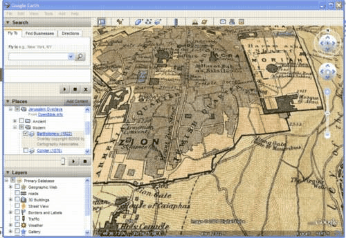 Tip: After installing GoogleEarth, here and click on "Open".
In "Places" click on "+" next to "Ancient" or "Modern" and tick one map.
Zoom in (hover over top right of map for the controls)
Then vary the transparency (the slider is in "Places")

Map Development & Research Tool - BibleMapper.com
Software with templates to create maps with your own annotations. Free registration.
Movie Maps - 90sec flash movies from MapsOfWar.com
Imperial History of the Middle East - empires changing since 3000 BC
History of Religions - birth and growth of religions since 3000 BC
Interactive Map of the Holy Land - BearPort.org
A downloadable program linking a photo and description to about
150 places on a satellite map (useful if you have an intermittent web connection)
2) Traditional maps & powerpoint maps
 Teaching maps - eBibleTeacher.com
50 simple but good-looking maps with large text for OT, NT
Maps & Charts Documenting the Expansion of Christianity - Yale University
300 historical maps and charts from atlases and the Yale University Map Collection
Historical & Cultural Atlas - Oregon University
30 clear maps for historical background of surrounding countries
Clickable map of ancient Palestine - Bible-History.com
Basic information is displayed at the top when you click on a place-name.

Students' maps of the Greek & Roman World - AWMC
50 maps collected by the producers of the wonderful Barrington Atlas of the Greek and Roman world (which, unfortunately, is not available on the web, even as a subscription site. A great pity!).
Place Names of the Greek & Roman world - AWMC
600 places with links to articles or websites. It is also worth checking their Pleiades ancient place names project, which is slowly growing, and will be a wonderful resource.
Historical Maps of the Middle East - Univisity of Texas
60 high resolution scans of mostly early 20th C maps (plus modern CIA maps of the Middle East)
Maps of the Roman Empire - LacusCurtius
Detailed older maps with Roman place names linked to Pliny's Natural History.
Not finished yet, but it will be a wonderful resource when it is.

Ancient Maps of Jerusalem - University of Southern Maine
30 mostly 12th C - 19th C, as high-resolution scans with useful commentary.
Jerusalem in Old Maps - Israel Ministry
14 maps in a chronological survey with useful commentary. Small images.
Many other maps collected by PreceptAustin.org
Lists of individual maps or small collections on various websites
3) Photos of places & archaeology
 Holy Land Photos
2900 photos listed by site, with very useful descriptions
Pictorial Library of Bible Lands - BiblePlaces.com
6000 photos well organised with very helpful descriptions. Free 400px previews.
Archaeological sites in the Middle East - Southwestern Baptist Theological Seminary
1200 photos of archaeological sites labelled merely with a place name.
Ancient Near Eastern and Mediterranean Sites - Emory University
500 photos of archaeological remains, labelled by place and objects.
Historical sites in the Holy Land - BibleWalks.com
200 locations with photographic essays. Good preparation for a visit.
Guide to Ephesus - Kusadasi.biz
Iron-Age Archaeology sites in Israel - eBibleTools
7 sites each with many photos and some videos.
Hint. If you aren't using many pictures, wait till the latter half of your teaching,
and then wake them up with a map and some photos.
skip to main |
skip to sidebar


 Posts
Posts
Posts
Posts
Keep me informed:
.
Subjects
- Arabic and Islamic teaching (1)
- Archaeology (1)
- Backups (3)
- Bible software (14)
- Bible translations (5)
- Bibles in ancient languages (8)
- BibleWorks (2)
- Bibliography software (2)
- Book buying + selling (1)
- Church history (3)
- Communicating (1)
- Egyptology + Hieroglyphics (1)
- Electronic books (11)
- Geography (1)
- Graeco-Roman background (2)
- Greek + Hebrew fonts (8)
- Greek + Latin texts (3)
- Indexing a book (2)
- Jewish background (3)
- Journals on the web (5)
- Lexicons for ancient languages (5)
- Library catalogues (6)
- Logos Libronix (2)
- Maps (1)
- News on the web (2)
- Palm + Pocket PC Bible tools (6)
- Pictures for Bible teaching (1)
- Publishing (3)
- Qur'an (Koran) (1)
- Rabbinics (1)
- Research tools (5)
- Scanning (3)
- Sermon and Worship resources (1)
- Syriac Bibles (1)
- Translation software (1)
- Viruses and spam (1)
- Web searches (2)
- Word processing (5)


7 comments:
Wow! What an amazing list. Thank you so much for compiling this!
Thanks for this list, David. For some other info on biblical mapping resources, I've been blogging about it here: bibleandtech.blogspot.com/search/label/biblical%20mapping
In particular, check out this page and note the Google Earth addins related to biblical places:
www.crossmarks.com/biblicalmapping/
I get kidded here at church because just about every time I preach I include a map or photo of some kind.
Thanks so much for this amazing list of great resources!
David, Another excellent post. Thanks for the Accordance plug as well. I would also mention the Bible Lands PhotoGuide which has over 1,600 photos, with annotations comparable to a pictorial encyclopedia.
In a way Tyndale House had a hand in this new release. Several of the photos that I took while traveling with the Summer School program last year made it in the new version.
it´s amazing find a webpage like this. I teach in a little seminary in Bogotá COlombia South America and it wil be very helpfull
Great site but doesn't Galatians say Mount Sinai is in Arabia which is Saudi Arabia or ancient Midian not Egypt? And the Sinai was never part of Arabia as it was looked over by Egyptian outposts.
Gal 4:25 For this Agar is mount Sinai in Arabia, and answereth to Jerusalem which now is, and is in bondage with her children.
Post a Comment